
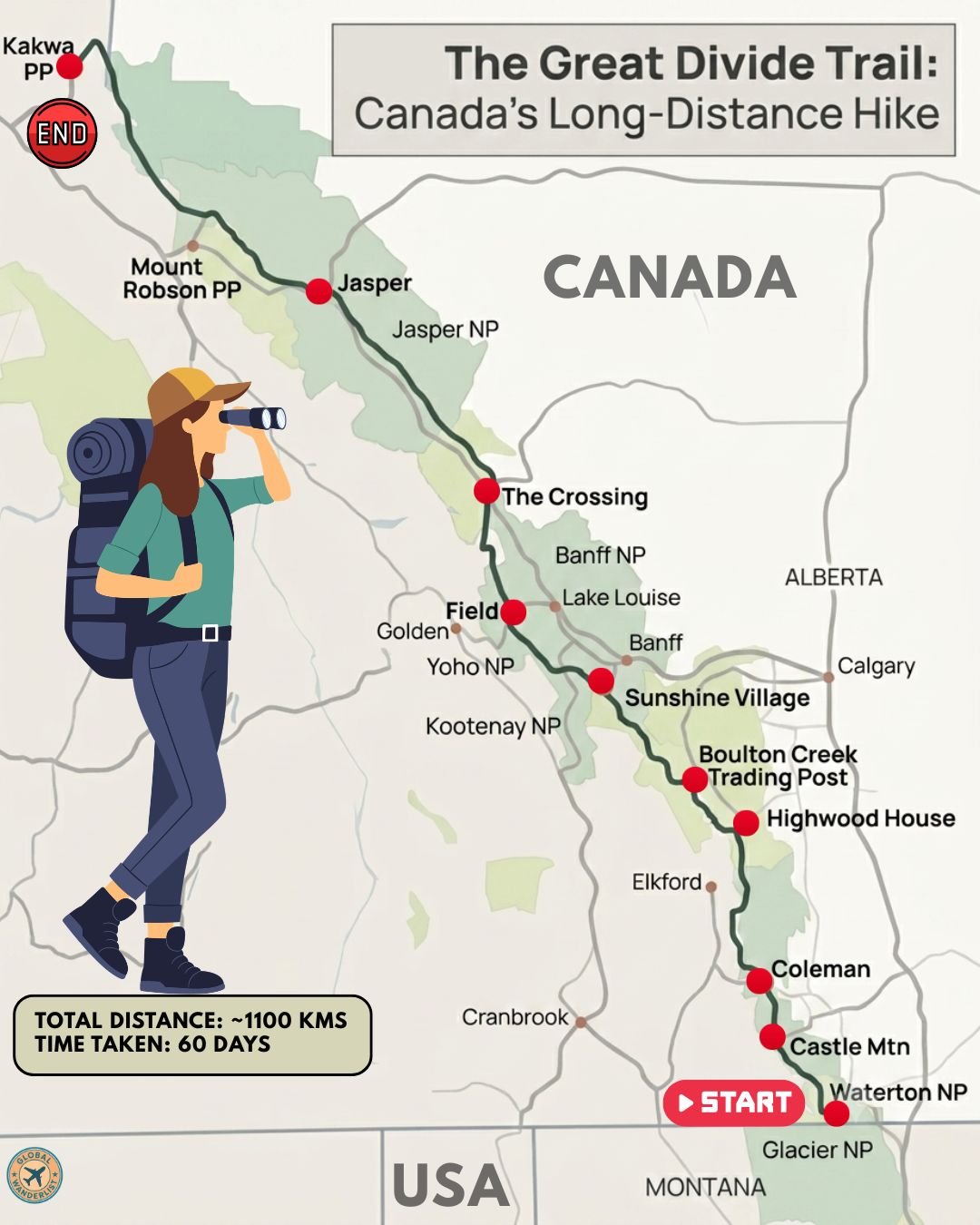
The Great Divide Trail is Canada’s most demanding long-distance hiking route, stretching roughly 1,100 kilometers through the heart of the Rocky Mountains between Alberta and British Columbia. Starting at the US border in Waterton Lakes National Park and finishing at remote Kakwa Lake, the trail crosses the continental divide more than 30 times. Most thru-hikers take between 30 and 60 days to complete it, depending on pace and how many alternate routes they take.
Unlike more established trails, the GDT is not a single continuous path. It stitches together existing park trails, old fire roads, and genuine cross-country wilderness routes, meaning navigation skills matter as much as fitness. The trail passes through five national parks and eight provincial parks, with roughly 60 percent of its length inside protected Rocky Mountain wilderness. Below is a full breakdown of the route, along with what to see and practical tips for each stretch.
Route Overview
| Section | Approx. Distance from Previous Stop | Terrain Highlight |
| Waterton Lakes National Park (Start) | – | Border peaks, alpine meadows |
| Castle Mountain & Coleman | 100 km | Coal-mining heritage, ridgelines |
| Highwood House & Boulton Creek | 90 km | Kananaskis Country lakes |
| Sunshine Village | 80 km | Banff high alpine terrain |
| Field & Yoho National Park | 90 km | The Rockwall, waterfalls |
| The Crossing & Jasper | 200 km | Icefields, glacier views |
| Mount Robson & Kakwa Lake (End) | 220 km | Remote wilderness, tallest peak |
Total trail distance runs approximately 1,100 kilometers. Most hikers tackle it northbound to follow the receding snowpack, since the short Rocky Mountain summer between July and September leaves little margin for error.
Waterton Lakes National Park to Castle Mountain
The Great Divide Trail begins at a survey monument on the US border, connecting directly to the northern end of the Continental Divide Trail in Montana. From here, the route climbs immediately into Waterton Lakes National Park, part of the Waterton-Glacier International Peace Park. The trail then continues north toward Castle Mountain and the old coal town of Coleman.
Trail Highlights
- Walk through Waterton Lakes National Park’s dramatic border peaks, where the prairies meet the Rockies with striking abruptness.
- Pass through Castle Provincial Park, known for its ridgelines and relatively quiet, less-trafficked terrain compared to Banff further north.
- Visit Coleman, a former coal-mining town that now serves as a key resupply point for hikers.
Planning Tips for This Section
- Secure your Parks Canada backcountry permits well in advance, since Waterton and the national parks further north require reservations through a competitive process.
- Carry bear spray and know how to use it, since grizzly activity is common throughout this stretch.
- Expect strong winds through Waterton, a known characteristic of this section given its exposure to prairie air masses.
Coleman to Highwood House and Boulton Creek
North of Coleman, the trail enters Kananaskis Country, a network of provincial parks known for its lakes and accessible mountain scenery. Highwood House and Boulton Creek Trading Post both serve as resupply points along this stretch. This section offers a mix of forested valleys and open ridge walks.
Trail Highlights
- Pass through the Kananaskis Lakes area, known for its turquoise, glacier-fed water and surrounding peaks.
- Walk sections of trail shared with day hikers, given Kananaskis Country’s popularity with Calgary-based weekend visitors.
- Resupply at Boulton Creek Trading Post, one of the more reliable stores along the entire route.
Planning Tips for This Section
- Check for area closures before setting out, since sections of Kananaskis Country occasionally close due to bear activity.
- Take advantage of relatively easy resupply logistics here compared to more remote sections further north.
- Watch the weather closely, since afternoon thunderstorms are common in this part of the Rockies during summer.
Highwood House to Sunshine Village
Continuing north, the trail passes into Banff National Park, Canada’s oldest and most famous protected area. Sunshine Village, a high-alpine ski resort in summer operation, marks a key point along this stretch. The terrain here shifts into some of the most dramatic high alpine scenery on the entire trail.
Trail Highlights
- Walk through Banff National Park’s high alpine meadows, particularly vivid with wildflowers in July.
- Pass near Sunshine Village, where seasonal services sometimes offer a rare hot meal for thru-hikers.
- Look for mountain goats and bighorn sheep, both common sightings along this exposed ridge terrain.
Planning Tips for This Section
- Book Banff National Park backcountry permits early, since this section is among the most popular and permit-restricted on the entire trail.
- Carry an ice axe if attempting early-season passes, since snow can linger into July at higher elevations.
- Confirm Sunshine Village’s seasonal operating hours before relying on it for resupply, since services vary by year.
Sunshine Village to Field and Yoho National Park
This stretch carries the trail into Yoho National Park, home to the Rockwall, one of the most celebrated hiking routes in the Canadian Rockies. Field, a small railway town, serves as a key resupply stop. The scenery here includes dramatic limestone cliffs and some of the trail’s most photographed waterfalls.
Trail Highlights
- Hike the Rockwall, a nearly 300-meter limestone escarpment considered one of the trail’s signature features.
- Visit Takakkaw Falls, one of the highest waterfalls in Canada, a short detour from the main route.
- Resupply in Field, a small but well-equipped railway town within Yoho National Park.
Planning Tips for This Section
- Reserve Yoho National Park backcountry campsites well ahead of your hike, since the Rockwall section fills quickly during peak season.
- Watch for river crossings that can become dangerous after heavy rain or rapid snowmelt.
- Take a rest day in Field if your schedule allows, since it offers some of the better resupply options along the entire trail.
Field to The Crossing and Jasper
North of Field, the trail passes near The Crossing, a resort along the Icefields Parkway, before continuing toward Jasper National Park. This stretch includes some of the most remote and physically demanding terrain on the GDT, with long stretches between reliable resupply points. Jasper itself marks one of the trail’s most significant towns.
Trail Highlights
- Pass beneath the Columbia Icefield region, home to some of the largest glaciers in the Canadian Rockies.
- Walk through Jasper National Park’s vast wilderness, Canada’s largest national park in the Rockies by area.
- Resupply in the town of Jasper, one of the few full-service stops along the entire trail.
Planning Tips for This Section
- Budget carefully for The Crossing, since it is known among hikers as an expensive resupply option compared to other stops.
- Plan extra food buffer for this stretch, since distances between reliable resupply points can extend for many days.
- Watch cell service closely, since coverage is minimal to nonexistent for long stretches through this section.
Jasper to Mount Robson and Kakwa Lake
The trail’s final stretch pushes north from Jasper toward Mount Robson, the highest peak in the Canadian Rockies, before continuing into the genuinely remote wilderness of Kakwa Provincial Park. This section includes some of the most difficult route-finding on the entire GDT, with sections requiring off-trail travel. Reaching Kakwa Lake marks the trail’s official northern terminus, installed in 2023.
Trail Highlights
- View Mount Robson, the tallest peak in the Canadian Rockies, from several dramatic vantage points along this stretch.
- Traverse Willmore Wilderness Park, one of the least developed and most remote sections of the entire trail.
- Finish at Kakwa Lake, where a public cabin with a wood stove offers a fitting place to rest after completing the trail.
Planning Tips for This Section
- Plan your exit logistics carefully before starting this section, since Kakwa Lake sits roughly 28 kilometers from the nearest trailhead with vehicle access.
- Carry a satellite communicator, since this stretch offers some of the least reliable cell coverage on the entire route.
- Budget extra days for road walking or hitching out from Kakwa, since transportation logistics here are widely considered the trail’s final challenge.
Final Thoughts
The Great Divide Trail offers one of the most demanding and rewarding long-distance hikes in North America, tracing the spine of the Canadian Rockies through five national parks and countless provincial wilderness areas. Its lack of a single continuous, well-marked path is part of what makes it so respected among serious long-distance hikers. Secure your permits early, prepare thoroughly for remote resupply logistics, and give yourself the full six to eight weeks the trail typically demands.