
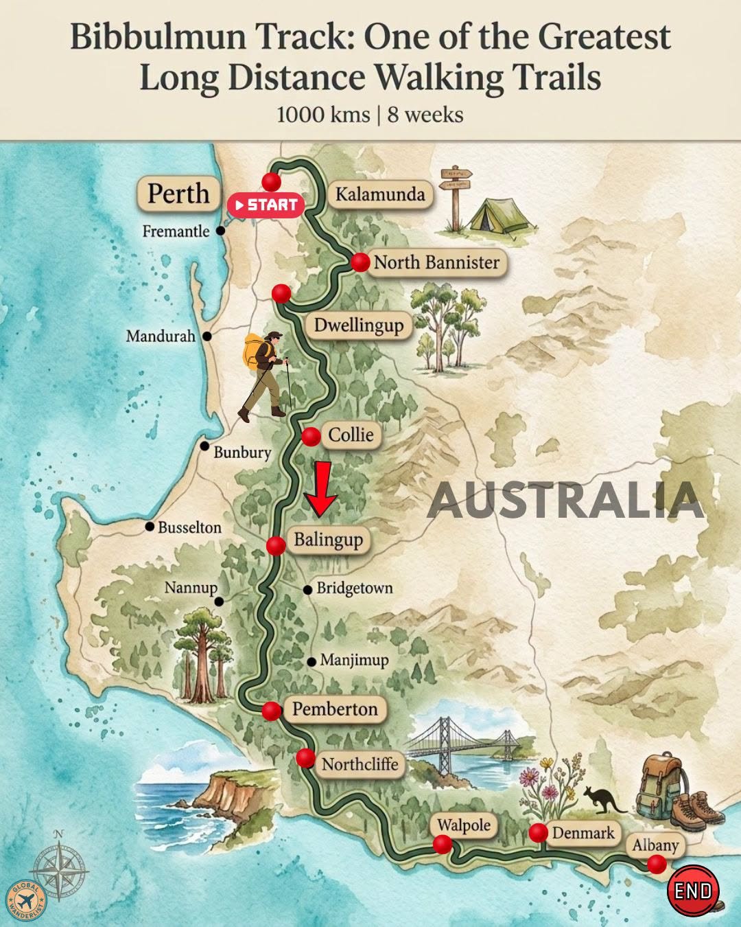
The Bibbulmun Track ranks among the world’s great long-distance walking trails, stretching 1,000 kilometers from the Perth Hills to the south coast at Albany. Most thru-hikers take around eight weeks to complete it, though the trail is just as popular as a series of shorter section hikes. Along the way, walkers pass through towering karri forests, historic timber towns, and dramatic Southern Ocean coastline.
The trail is named after the Bibbulmun, a group of Noongar people who once traveled long distances on foot through this same country. Every few hundred meters, a yellow triangular marker depicting the Waugal, the rainbow serpent of the Dreaming, confirms you are still on track. Below is a full breakdown of the route, along with what to see and practical tips for each stretch.
Route Overview
| Section | Approx. Distance from Previous Stop | Terrain Highlight |
|---|---|---|
| Kalamunda, Perth (Start) | – | Jarrah forest, trailhead |
| North Bannister | 75 km | Open woodland |
| Dwellingup | 60 km | Historic timber town |
| Collie | 75 km | Coal-mining heritage |
| Balingup | 60 km | Rolling farmland |
| Pemberton | 100 km | Towering karri forest |
| Northcliffe | 30 km | Forest and farmland |
| Walpole | 110 km | Inlets and tall trees |
| Denmark | 65 km | Wineries and coast |
| Albany (End) | 55 km | Granite coastline |
Total trail distance runs just over 1,000 kilometers. Distances between campsites range from about 10 kilometers in the northern sections to 20 to 25 kilometers further south, so pacing naturally slows down as the trail nears the coast.
Kalamunda to North Bannister
The Bibbulmun Track begins in Kalamunda, a suburb in the hills just east of Perth. The opening stretch winds through jarrah forest and past reservoirs that supply the city’s water. This northern section is broken into shorter half-day walks, making it a gentler introduction before the trail lengthens further south.
Trail Highlights
- Pass through Mundaring Weir, an early water supply dam with a striking pipeline that once fed the Goldfields. The wall closes at 5 p.m., so plan your crossing time accordingly.
- Walk through open jarrah and marri woodland, home to kangaroos, echidnas, and a wide variety of native birds.
- Look for wildflowers if walking in spring, when the understory bursts into color across this stretch.
Planning Tips for This Section
- Carry a printed map or offline GPS app alongside the Waugal markers, since long straight stretches sometimes go without a marker for a while.
- Start early in the day during warmer months, since this northern section carries the highest bushfire risk on the entire trail.
- Book accommodation in Dwellingup ahead of time if you plan to break your walk there, since it is a popular stop for both hikers and cyclists.
Dwellingup to Collie
Dwellingup is a small timber town that has rebuilt itself after a devastating 1961 bushfire swept through the region. From here, the trail continues south into karri and jarrah forest before reaching Collie, a town built on its coal-mining history. This stretch offers a good mix of forest walking and small-town resupply points.
Trail Highlights
- Visit the Hotham Valley Railway in Dwellingup, home to a heritage steam train that still runs through the surrounding forest.
- Walk beside the Murray River, one of the trail’s most scenic river crossings in this section.
- Explore Collie’s mining heritage, including old headframes that reflect the town’s industrial past.
Planning Tips for This Section
- Refill water at official campsite tanks, but always treat or boil rainwater collected from tanks before drinking it.
- Check for prescribed burn diversions before setting out, since planned burns in this region can temporarily reroute the trail.
- Use Dwellingup or Collie as a resupply point, since both towns have shops within easy reach of the trail.
Balingup to Pemberton
South of Collie, the trail passes through Balingup, a small rural village surrounded by rolling farmland. From here, it continues toward Pemberton, home to some of the tallest trees in the karri forest. This stretch marks a noticeable shift from open woodland into much denser, taller forest.
Trail Highlights
- Climb the Gloucester Tree near Pemberton, one of the tallest fire lookout trees in the world, using its exposed metal rungs.
- Walk beneath towering karri trees, some of the tallest hardwood trees on Earth, found almost exclusively in this region.
- Visit Balingup’s small craft and produce stores, a pleasant break from forest walking.
Planning Tips for This Section
- Pack extra layers for this stretch, since the dense karri canopy keeps temperatures noticeably cooler than the open sections further north.
- Time your visit to the Gloucester Tree for daylight hours, since the climb is not recommended in low light.
- Stock up on supplies in Pemberton, one of the larger towns along the entire route.
Northcliffe to Walpole
Northcliffe sits at the edge of the karri forest, marking the transition toward the trail’s southern coastal stretches. From here, the Bibbulmun continues through forest and farmland before reaching Walpole, known for its tall tingle trees and scenic inlets. This section includes some of the trail’s most peaceful river and forest scenery.
Trail Highlights
- Explore the Valley of the Giants Tree Top Walk near Walpole, a suspended walkway among towering tingle trees found nowhere else in the world.
- Walk beside the Frankland and Deep Rivers, both known for their calm, tannin-stained waters.
- Visit Walpole’s inlet system, a peaceful estuary popular with kayakers and birdwatchers.
Planning Tips for This Section
- Watch for tiger snakes and dugites in warmer months, both native to this region. Stay on the marked trail and give any snakes space to move away.
- Restock food supplies in Northcliffe or Walpole, since options become sparser once you continue toward Denmark.
- Check campsite shelter conditions ahead of time during winter, since this section receives the highest rainfall on the trail.
Denmark to Albany
The final stretch of the Bibbulmun Track moves along the south coast, passing through Denmark before finishing in Albany. Granite headlands, wineries, and dramatic coastal cliffs define this closing section. Reaching Albany marks the end of a walk that has covered nearly every landscape in Western Australia’s southwest.
Trail Highlights
- Visit Denmark’s wineries, many offering cellar door tastings within a short detour from the trail.
- Walk along William Bay National Park’s coastline, including the calm, granite-sheltered Greens Pool.
- Finish at Albany’s southern terminus near the Visitor Centre, close to dramatic formations like The Gap and Natural Bridge.
Planning Tips for This Section
- Arrange transport or accommodation in Denmark ahead of time, since it is a popular final resupply point before the coastal push to Albany.
- Expect stronger coastal winds along this stretch, particularly around exposed headlands near William Bay.
- Celebrate your finish at the Albany Visitor Centre, the trail’s official southern terminus since a recent realignment.
Final Thoughts
The Bibbulmun Track offers one of Australia’s most complete long-distance walking experiences, moving from Perth’s forested hills to the granite coastline of the south. Every section shifts the scenery noticeably, from timber towns to towering karri forest to windswept headlands. Plan around the cooler months between autumn and spring, and let the trail’s steady rhythm carry you all the way to Albany.