
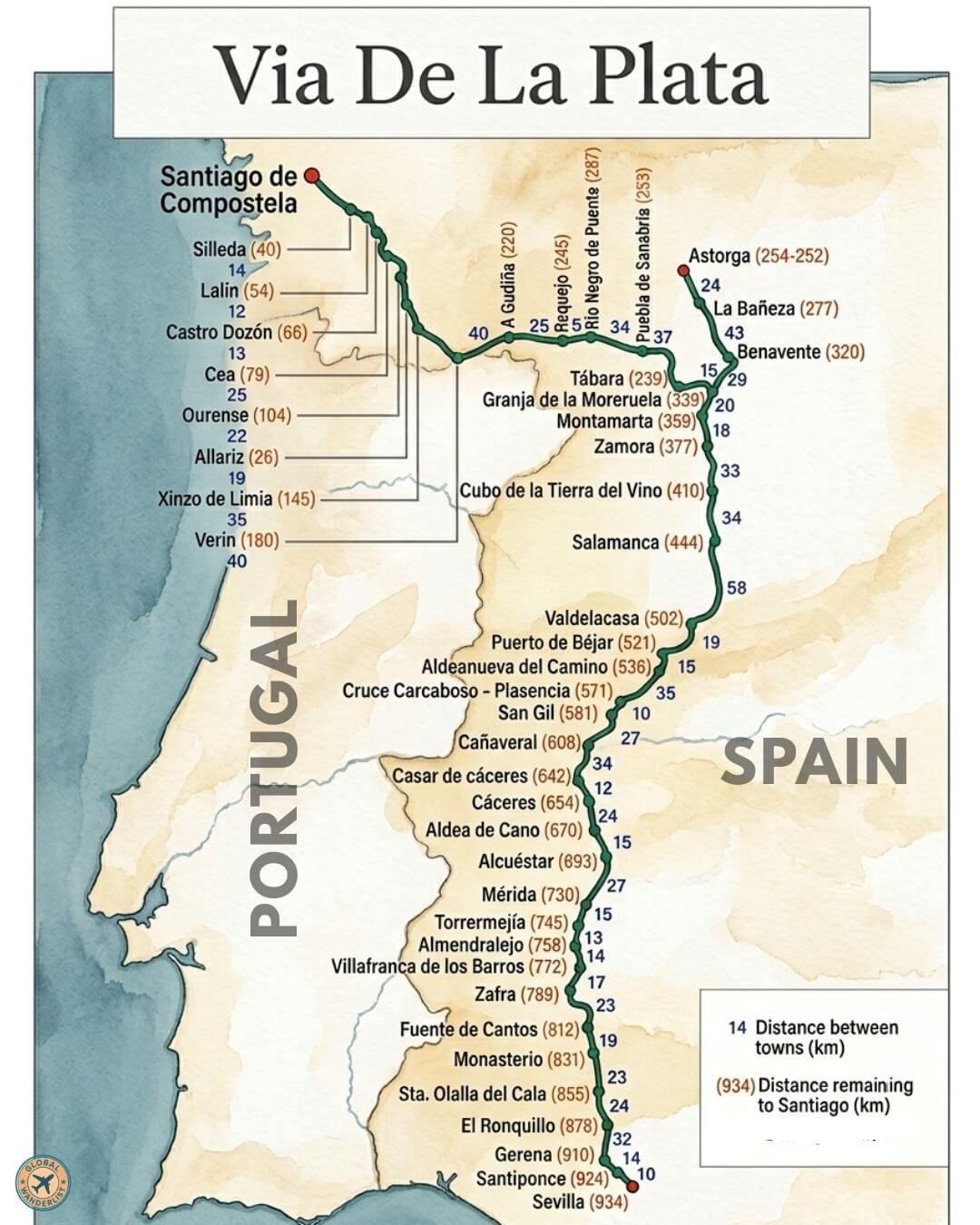
Of all the pilgrimage paths that make up the network of Caminos de Santiago crisscrossing Spain, the Via de la Plata stands apart for one simple reason: distance. Stretching 934 kilometres from Sevilla in the sun-baked south to Santiago de Compostela in the green, rain-fed north, it is the longest of the established Camino routes, cutting through the entire length of the Iberian Peninsula and, in doing so, through nearly every landscape and climate Spain has to offer. Where the Camino Francés draws crowds of pilgrims shoulder to shoulder through the Pyrenees, the Via de la Plata remains comparatively quiet, a route for those who want solitude, history, and a genuine sense of covering serious ground on foot.
A Roman Road Turned Pilgrim’s Path
The name itself hints at the route’s ancient origins. “Via de la Plata” translates roughly as the “Silver Route,” though historians debate whether this refers to actual silver transported along it or is a corruption of an old Arabic or Latin term for a paved road. What’s certain is that the route follows the corridor of an old Roman road, originally built to connect the mines and cities of the south with the northwest of the peninsula. Centuries later, as the cult of Saint James grew and pilgrims began streaming toward his shrine in Santiago de Compostela, this existing infrastructure became a natural artery for those setting out from Andalusia and Extremadura.
Walking the Via de la Plata today means walking through layers of history stacked on top of one another: Roman milestones and bridges, Moorish influence still visible in the architecture of southern towns, medieval churches and pilgrim hospitals, and eventually the lush, Celtic-influenced landscapes of Galicia in the far northwest.
Starting Out: Sevilla to Extremadura
The journey begins in Sevilla, one of Spain’s most vibrant cities, its Gothic cathedral and Moorish Alcázar palace offering pilgrims a grand send-off before the long walk north. From Sevilla, the route passes through Santiponce and Gerena before reaching El Ronquillo, easing walkers into the rhythm of the trail across the rolling farmland and cork oak forests of Andalusia.
The path continues north through Santa Olalla del Cala and Monasterio, small towns that mark the gradual transition from Andalusia into Extremadura, one of Spain’s least populated and most historically rich regions. Fuente de Cantos and Zafra follow, the latter known for its handsome Renaissance-era square and castle, before the route arrives in Villafranca de los Barros and Almendralejo, towns set amid vineyards that produce much of Extremadura’s wine.
Mérida: A Roman Jewel on the Route
Few stops on the entire Via de la Plata match the historical weight of Mérida. Founded by the Romans as Emerita Augusta, the city preserves one of the best-conserved collections of Roman ruins anywhere in Spain, including a dramatic amphitheatre, a well-preserved theatre still used for performances today, and a Roman bridge that pilgrims cross on their way through town. For many walkers, Mérida marks one of the most memorable overnight stops of the entire route, a chance to rest in a city where the Roman roots of the Camino itself feel especially tangible.
From Mérida, the trail passes through Torremejía before continuing toward Alcuéstar and Aldea de Cano, quiet farming villages set against the wide, open plains of Extremadura known as the dehesa, a landscape of scattered oak trees and grazing livestock that has barely changed in centuries.
Cáceres and the Heart of Extremadura
The historic city of Cáceres offers another highlight, its old town a UNESCO World Heritage Site packed with medieval and Renaissance palaces, church towers, and stork nests perched improbably on ancient stonework. Walking into Cáceres after days on quieter rural paths, pilgrims often describe the sudden shift in scale, from empty countryside to a dense, atmospheric old town that has changed remarkably little since the Middle Ages.
North of Cáceres, the route passes through Casar de Cáceres before reaching Cañaveral, and then San Gil and the crossing near Carcaboso and Plasencia. Plasencia itself, though slightly off the direct line for some walkers, is a notable detour point thanks to its cathedral and lively market tradition. The path continues through Aldeanueva del Camino and Puerto de Béjar, where the terrain begins to rise, signalling the approach to the mountainous border between Extremadura and Castilla y León.
Crossing into Castilla y León: Salamanca and the Meseta
At Valdelacasa, walkers cross into Castilla y León, and the character of the route shifts again. Ahead lies Salamanca, one of Spain’s great university cities and, for many pilgrims, the emotional and cultural high point of the southern half of the Via de la Plata. Salamanca’s golden sandstone buildings, its enormous Plaza Mayor, and its centuries-old university (among the oldest in Europe) make it a natural place to pause for a rest day before continuing north.
From Salamanca, the route enters the wide, flat expanse of the Meseta, Spain’s high central plateau, passing through Cubo de la Tierra del Vino, a name that nods to the area’s winemaking history, before reaching Zamora. Zamora is celebrated for its exceptional concentration of Romanesque churches, said to be one of the highest densities of Romanesque architecture anywhere in Europe, a legacy of the city’s importance during the medieval Reconquista.
The path continues through Montamarta and Granja de la Moreruela, home to the ruins of a once-important monastery, before reaching Tábara. From here, walkers face one of the more consequential decisions on the entire Via de la Plata: whether to continue on the traditional route toward Puebla de Sanabria and the mountainous Sanabria region, or to branch onto the Camino Sanabrés, a variant that many modern pilgrims prefer for its more direct and scenic path toward Galicia.
The Sanabrés Variant and the Approach to Galicia
For those following the Sanabrés route through Puebla de Sanabria, the trail climbs through increasingly mountainous, forested terrain, a dramatic contrast to the flat plains left behind. This section passes through Requejo and A Gudiña before crossing into the region of Galicia itself, where the landscape turns noticeably greener and wetter, shaped by the Atlantic climate that defines Spain’s northwest corner.
Meanwhile, walkers who choose the more traditional line through Astorga join instead with the Camino Francés, passing through La Bañeza and Benavente on a route that eventually merges with Spain’s most famous pilgrim path before reaching Galicia by a different line entirely. This split is one of the defining features of the Via de la Plata: unlike more linear Caminos, it offers genuine route choices in its final third, each with a distinct character.
Galicia: The Final Stretch to Santiago
Whichever branch pilgrims take, the final approach to Santiago winds through the same lush Galician countryside that defines the end of every major Camino route: eucalyptus and pine forests, stone farmhouses, and small villages built around parish churches. Along the Sanabrés variant, the route passes through Verín and Xinzo de Limia, then Allariz, a particularly picturesque medieval town built along the banks of the River Arnoia, and on to Ourense, known for its natural thermal springs, a welcome luxury for tired feet after weeks of walking.
From Ourense, the path continues through Cea, famed locally for its traditional bread, and Castro Dozón, before reaching Lalín and Silleda as the route enters its final stages. The last stretch into Santiago de Compostela follows the same emotional arc familiar to pilgrims on every Camino: growing anticipation, the first glimpses of the cathedral’s spires, and finally arrival in the Praza do Obradoiro, the grand square in front of Santiago’s cathedral, where the remains of Saint James are said to rest.
Practical Considerations for Walking the Via de la Plata
The sheer length of the Via de la Plata, 934 kilometres from Sevilla to Santiago, means most pilgrims need between five and six weeks to complete it in full, walking an average of 25 to 30 kilometres a day. This makes it a significantly larger undertaking than the Camino Francés, both physically and logistically.
Climate is a major factor in planning. The southern stretches through Andalusia and Extremadura can be brutally hot in summer, with temperatures regularly exceeding 40 degrees Celsius in July and August, making spring and autumn the preferred seasons for most walkers. The northern stretches through Galicia, by contrast, are cooler and wetter year-round, so pilgrims often need to prepare for genuinely different weather conditions within the same trip.
Infrastructure along the route, while well-established, is generally less developed than on the Camino Francés. Albergues (pilgrim hostels) exist along the way but are more spread out, and some stretches, particularly through rural Extremadura, involve longer gaps between towns with services. This makes advance planning, particularly around water and food supplies for longer stages, more important than on busier routes.
For those seeking a Camino experience defined by solitude, historical depth, and a genuine sense of crossing an entire country on foot, the Via de la Plata remains one of the most rewarding options in Spain. It trades the camaraderie and infrastructure of the busier routes for something quieter: long days walking through Roman ruins, medieval towns, vast open plains, and finally the green hills of Galicia, arriving at the same destination that has drawn pilgrims for over a thousand years.