
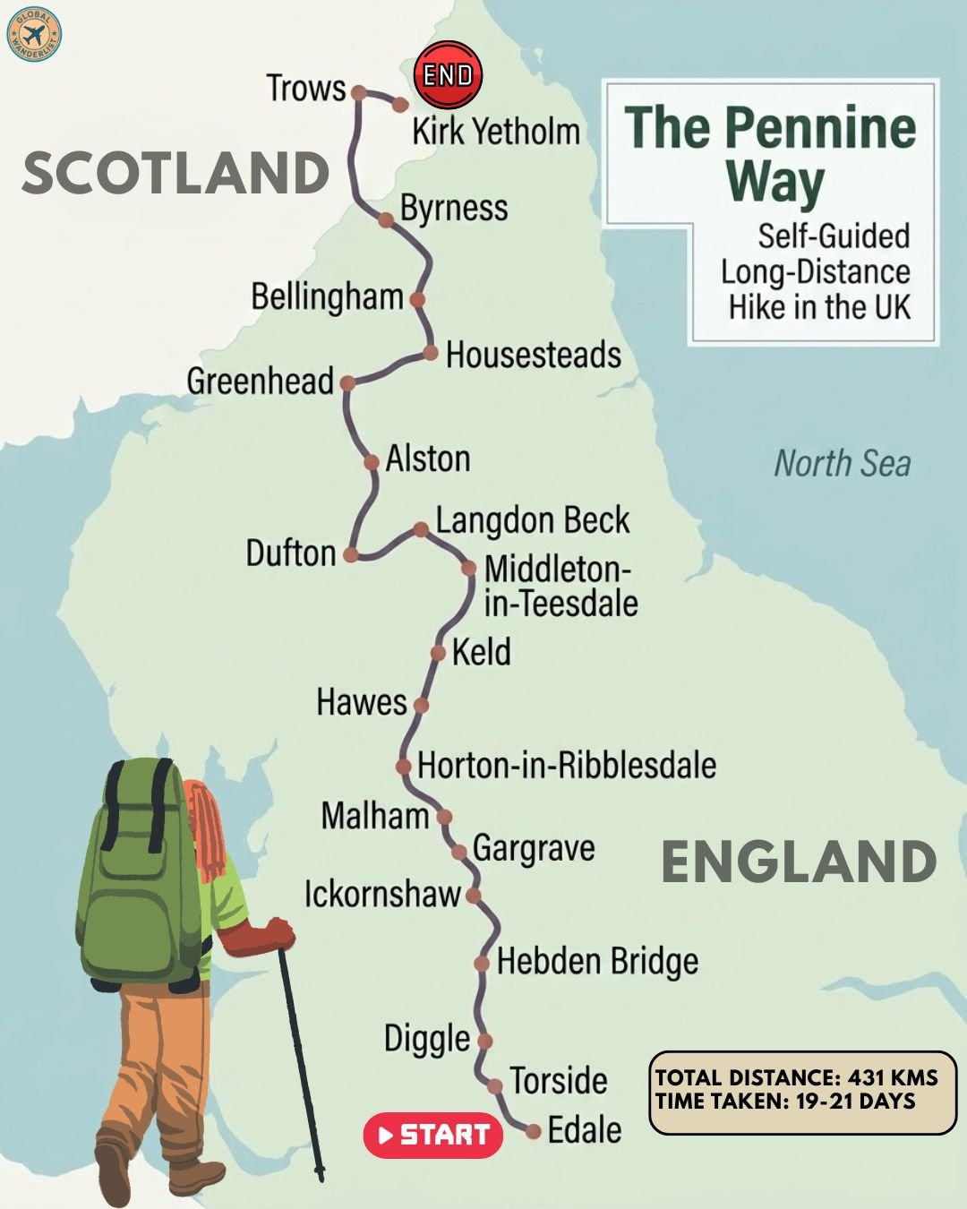
The Pennine Way is Britain’s oldest official long-distance footpath. It runs 431 kilometers from the Peak District to the Scottish border. Hikers cross wild moorland, limestone dales, and the remote Cheviot Hills.
This trek is not a casual weekend stroll. Expect boggy ground, sudden weather shifts, and long exposed ridgelines. Most walkers need 19 to 21 days to finish the full route.
The scenery changes constantly. Gritstone edges give way to waterfalls, then to Roman ruins, then to empty heather hills near Scotland. Wildlife sightings include curlews, red grouse, and the occasional mountain hare.
This trail suits experienced hikers who enjoy self-navigation and basic accommodation. Fitness matters more than technical climbing skill. Good waterproof gear and solid boots are essential year-round.
Early planning pays off. Many rural guesthouses and bunkhouses have limited beds. Booking ahead, especially between May and September, keeps your itinerary stress-free.
Pennine Way Trek Stop Summary
| Trek Stop | Elevation | Distance from Previous Stop | Estimated Hiking Time | Overnight Stay |
|---|---|---|---|---|
| Edale | 160 m | Start point | – | YHA Edale, local B&Bs |
| Torside | 245 m | 26 km | 7-8 hours | Crowden campsite |
| Diggle | 200 m | 18 km | 5-6 hours | Diggle B&Bs |
| Hebden Bridge | 140 m | 26 km | 7-8 hours | Guesthouses, hotels |
| Ickornshaw | 245 m | 23 km | 6-7 hours | Cowling B&Bs |
| Gargrave | 150 m | 10 km | 3 hours | Village inns |
| Malham | 180 m | 10 km | 3 hours | YHA Malham, Lister Arms |
| Horton-in-Ribblesdale | 325 m | 23 km | 6-7 hours | Bunkhouses, pub rooms |
| Hawes | 250 m | 22 km | 6-7 hours | YHA Hawes, hotels |
| Keld | 275 m | 21 km | 6 hours | Keld Lodge, campsite |
| Middleton-in-Teesdale | 230 m | 18 km | 5 hours | Teesdale Hotel |
| Langdon Beck | 370 m | 13 km | 3-4 hours | Langdon Beck Hotel |
| Dufton | 200 m | 20 km | 6 hours | Redstones, campsite |
| Alston | 300 m | 31 km | 9-10 hours | Alston Hostel |
| Greenhead | 180 m | 27 km | 7-8 hours | Greenhead Hotel, B&Bs |
| Housesteads | 250 m | 11 km | 3 hours | Twice Brewed Inn area |
| Bellingham | 160 m | 24 km | 6-7 hours | Cheviot Hotel, camping |
| Byrness | 180 m | 24 km | 6-7 hours | Forest View Walkers Inn |
| Trows | 400 m | Along final ridge | Part of final day | Mountain refuge hut |
| Kirk Yetholm | 180 m | 43 km | 10-12 hours | Kirk Yetholm hostel, Border Hotel |
Distances and times are approximate averages based on typical hiker pace and weather conditions.
Edale: The Starting Line in the Peak District
Edale sits at the foot of Kinder Scout, the Peak District’s highest plateau. Stone cottages and green fields make it a peaceful launch point. Most hikers arrive by train the night before starting.
The village has served walkers for generations. Its small church and old pub give it genuine character before the wild moorland begins.
Where to Stay in Edale
YHA Edale offers dorm rooms and private options in a converted country house near Mam Tor. Ollerbrook Barn is a well-reviewed budget B&B close to the trailhead. The Rambler Inn provides comfortable rooms and hearty breakfasts just minutes from the start.
What to See in Edale
- Kinder Scout rises above the village and marks the trail’s first serious climb, with peat groughs and dramatic edges.
- Grindsbrook Clough offers a dramatic rocky approach to the plateau, popular with hikers testing their legs on day one.
- Mam Tor nearby delivers sweeping views over the Hope Valley and is worth a short detour before you begin.
- The Nag’s Head pub marks the official trail start and has served walkers since the path opened in 1965.
Torside: Reservoir Views After the First Big Push
Torside sits beside its namesake reservoir in the Longdendale Valley. After the punishing Kinder plateau, this stretch feels gentler. Water glints below darker moorland ridges.
The reservoir chain here once powered Manchester’s mills. Today it offers quiet reflection after a demanding opening stage.
Where to Stay in Torside
Crowden Camping and Caravanning Club site sits right on the trail and welcomes backpackers with basic but reliable facilities. It remains the standard overnight choice for this section, since the village itself has no hotels.
What to See in Torside
- Torside Reservoir reflects the surrounding hills and makes a scenic rest stop after a tough morning.
- Bleaklow Head tests navigation skills with featureless peat bog, so a map and compass matter here.
- Laddow Rocks offer a dramatic gritstone escarpment with views back toward Kinder Scout.
- Crowden Great Brook valley provides a green contrast to the darker moors above it.
Diggle: Gateway to the Standedge Moors
Diggle is a small former mill village near Saddleworth. Stone terraces and canal remnants hint at its industrial past. The Standedge Tunnel, once the longest canal tunnel in Britain, runs beneath the hills nearby.
Hikers pass through quickly, but the village offers a welcome pause before climbing back onto exposed moorland.
Where to Stay in Diggle
Accommodation directly in Diggle is limited, so many hikers book B&Bs in nearby Marsden or Uppermill, both a short taxi ride away. These villages offer reliable guesthouse options with strong recent reviews.
What to See in Diggle
- Standedge Tunnel entrance shows off remarkable Victorian canal engineering just off the main route.
- Millstone Edge offers gritstone outcrops popular with climbers and photographers alike.
- Wessenden Valley reservoirs create a chain of still water framed by heather moorland.
- Blackstone Edge marks the historic county boundary and features an ancient paved packhorse route.
Hebden Bridge: Independent Spirit in the Calder Valley
Hebden Bridge is a lively former mill town packed with independent shops and cafes. Steep valley sides and stone bridges give it a distinctive character. It has a reputation as an arts and culture hub.
Many hikers treat this as a rest day stop, restocking supplies and enjoying a proper meal before the next remote stretch.
Where to Stay in Hebden Bridge
The town has numerous well-rated guesthouses and small hotels within walking distance of the center. Angeldale Guest House and several other family-run B&Bs consistently receive strong reviews from passing hikers for comfort and warm hospitality.
What to See in Hebden Bridge
- Stoodley Pike Monument dominates the skyline and rewards the climb with panoramic valley views.
- The Rochdale Canal towpath offers a flat, scenic stretch through town for tired legs.
- Hardcastle Crags features ancient woodland and tumbling streams just a short detour away.
- The town’s independent bookshops and cafes make for a relaxing evening after tough terrain.
Ickornshaw: Quiet Moorland Crossing Near Cowling
Ickornshaw is a tiny hamlet near the larger village of Cowling. The surrounding moors feel remote despite being close to Yorkshire towns. Sheep pastures stretch toward distant wind farms.
This stretch marks a transition from the South Pennines into gentler Yorkshire Dales countryside.
Where to Stay in Ickornshaw
Most hikers stay in nearby Cowling or Lothersdale, where small guesthouses and the well-regarded Hare and Hounds Inn offer comfortable rooms and good food. Earby Hostel, an independent former YHA property, is another solid option slightly further along.
What to See in Ickornshaw
- Ickornshaw Moor offers wide-open heather views and a genuine sense of isolation.
- Lothersdale village provides a picturesque stop with a historic mill wheel still visible.
- Pinhaw Beacon rewards a short climb with distant views toward the Yorkshire Dales.
- Elslack Moor’s quiet reservoirs attract wading birds worth watching for.
Gargrave: A Gentle Riverside Break
Gargrave sits along the River Aire, offering flat walking and welcome shops. It marks the entrance to the Yorkshire Dales National Park. The pace of the trail noticeably softens here.
Many hikers restock food supplies in Gargrave before tackling the limestone country ahead.
Where to Stay in Gargrave
The Masons Arms and a handful of village B&Bs provide comfortable, well-reviewed rooms right on the trail. Gargrave’s small size means booking ahead during peak season is wise.
What to See in Gargrave
- The River Aire footpath offers easy, scenic walking through green farmland.
- St Andrew’s Church anchors the village with centuries of local history.
- The Leeds and Liverpool Canal passes nearby, popular with narrowboat travelers.
- Eshton Moor provides a quiet approach toward the dramatic limestone scenery ahead.
Malham: Limestone Country and Dramatic Cliffs
Malham is one of the most scenic villages on the entire route. Dramatic limestone formations surround it on all sides. This is a highlight stop for most Pennine Way hikers.
The geology here draws visitors well beyond hikers, including geology students and casual day-trippers from nearby towns.
Where to Stay in Malham
YHA Malham offers comfortable hostel accommodation with a strong reputation among long-distance walkers. The Lister Arms provides cozy pub rooms with excellent food, and Beck Hall offers a well-reviewed plant-based B&B and restaurant option.
What to See in Malham
- Malham Cove forms a massive curved limestone cliff, one of England’s most photographed natural landmarks.
- Gordale Scar features a dramatic gorge with waterfalls crashing between towering rock walls.
- Malham Tarn is a rare upland lake, important for wildlife and popular with birdwatchers.
- The limestone pavement atop the cove offers unusual, fractured rock formations worth exploring carefully.
Horton-in-Ribblesdale: Base for the Yorkshire Three Peaks
Horton-in-Ribblesdale sits beneath Pen-y-ghent, one of the Yorkshire Three Peaks. The village buzzes with hikers and cavers year-round. Its central cafe is a legendary refueling stop.
This stretch includes some of the trail’s most rewarding summit views before descending into Wensleydale.
Where to Stay in Horton-in-Ribblesdale
Three Peaks Bunkhouse and the Golden Lion pub both offer reliable, well-reviewed rooms popular with long-distance walkers. Booking ahead is strongly recommended since beds fill quickly during peak hiking season.
What to See in Horton-in-Ribblesdale
- Pen-y-ghent’s summit offers sweeping views across the Dales and a satisfying scramble near the top.
- Hull Pot is a spectacular natural sinkhole worth the short detour to see.
- Ribblehead Viaduct, though slightly off-route, is a stunning Victorian railway landmark nearby.
- Fountains Fell provides quieter, less crowded moorland walking before the Pen-y-ghent climb.
Hawes: England’s Highest Market Town
Hawes sits in upper Wensleydale, famous for its creamery and traditional market. The town feels lively and welcoming after remote moorland stretches. Local cheese shops make a fun stop for tired hikers.
Wensleydale’s rolling green hills provide a scenic contrast to the harsher terrain still ahead.
Where to Stay in Hawes
YHA Hawes sits minutes from the village center and consistently earns praise for its home-cooked food and friendly wardens. Herriot’s Hotel and several guesthouses also offer comfortable, well-reviewed rooms.
What to See in Hawes
- The Wensleydale Creamery offers tours and tastings of the region’s famous cheese.
- Hardraw Force, England’s tallest single-drop waterfall, sits just a short walk from the village.
- Hawes Ropemakers demonstrates a traditional craft that has survived for generations.
- The Dales Countryside Museum explains the area’s farming heritage in an engaging way.
Keld: Remote Heart of Upper Swaledale
Keld is a tiny hamlet where the Pennine Way crosses the Coast to Coast path. Waterfalls and stone barns surround the settlement. It feels wonderfully remote despite its small size.
This crossing point makes Keld a popular meeting spot for long-distance walkers heading in different directions.
Where to Stay in Keld
Keld Lodge offers comfortable rooms in a converted former shooting lodge with strong recent reviews. Park House campsite provides a reliable budget option for tent-based hikers.
What to See in Keld
- Kisdon Force is a powerful waterfall reached by a short, scenic riverside path.
- Wain Wath Force offers an easily accessible cascade just outside the village.
- Tan Hill Inn, Britain’s highest pub, lies a rewarding detour away across open moor.
- Swaledale’s stone barns and flower meadows showcase traditional Dales farming landscapes.
Middleton-in-Teesdale: Lead Mining Heritage in Upper Teesdale
Middleton-in-Teesdale grew around historic lead mining operations. Stone cottages and old mining buildings line its streets. The River Tees runs nearby, hinting at dramatic waterfalls further along the trail.
This town offers a good final restock point before the wilder stretches toward Cross Fell.
Where to Stay in Middleton-in-Teesdale
The Teesdale Hotel provides comfortable rooms and hearty meals with consistently positive recent reviews. Several village B&Bs offer additional budget-friendly alternatives.
What to See in Middleton-in-Teesdale
- The old lead mining buildings tell the story of the region’s industrial past.
- Bowlees Visitor Centre provides useful trail information and a pleasant riverside picnic spot.
- Low Force waterfall offers an accessible, powerful cascade close to town.
- The River Tees walking path sets up the dramatic scenery still to come upstream.
Langdon Beck: Waterfall Country Before the High Fells
Langdon Beck sits in genuinely remote upper Teesdale. This short stage covers dramatic waterfall scenery. The landscape becomes noticeably wilder as elevation increases.
Weather changes quickly here, so checking forecasts before setting out is essential.
Where to Stay in Langdon Beck
The Langdon Beck Hotel is the main option in this remote area and offers simple, comfortable rooms with reliable service for passing hikers.
What to See in Langdon Beck
- High Force is one of England’s most powerful waterfalls, thundering over dark whinstone cliffs.
- Cauldron Snout offers a dramatic cascading rapid further upstream, reached by a rocky scramble.
- Cow Green Reservoir provides stark, beautiful moorland reflections.
- Widdybank Fell hosts rare arctic-alpine plants found almost nowhere else in England.
Dufton: Gateway to High Cup Nick
Dufton is a picturesque village with a circular green and colorful cottages. It sits beneath the steep climb toward Cross Fell, the trail’s highest point. Many hikers consider this one of the most beautiful villages on the route.
The dramatic valley just beyond the village ranks among the trail’s most photographed sights.
Where to Stay in Dufton
Redstones, the former YHA property, now operates as an independently run hotel with positive recent reviews. A small village campsite offers a budget alternative for tent-based hikers.
What to See in Dufton
- High Cup Nick forms a spectacular U-shaped glacial valley often compared to a miniature Grand Canyon.
- Dufton’s village green offers a peaceful, colorful spot to rest before the big climb ahead.
- Dufton Pike provides an optional short summit detour with excellent valley views.
- The approach to Cross Fell begins here, so stocking up on water is essential.
Alston: England’s Highest Market Town Crossing
Alston sits after the trail’s most demanding stretch, crossing Cross Fell at 893 meters. Cobbled streets and old stone buildings give the town genuine charm. Hikers often need a rest day here.
This crossing is notorious for sudden weather changes, so timing and preparation matter enormously.
Where to Stay in Alston
Alston Hostel, formerly run by YHA, continues to operate independently with strong reviews from hikers. Garrigill Village Hall Bunkroom offers a simpler budget option a few miles before town.
What to See in Alston
- Cross Fell is the highest point on the Pennine Way and the highest peak in the Pennines.
- Great Dun Fell features a distinctive radar station visible for miles across the moor.
- Alston’s cobbled market square showcases some of England’s best-preserved historic streetscapes.
- The South Tynedale Railway offers a scenic narrow-gauge train ride for a rest-day outing.
Greenhead: Approaching Hadrian’s Wall
Greenhead marks the transition toward Roman history. The village sits just south of Hadrian’s Wall. Stone walls and rolling farmland set the scene for the famous section ahead.
This stretch feels historically rich compared to the wilder moorland crossed earlier.
Where to Stay in Greenhead
The Greenhead Hotel offers solid rooms and meals with good recent reviews. Holmhead B&B, set in a converted farmhouse near the wall itself, is another well-regarded local option.
What to See in Greenhead
- Thirlwall Castle ruins stand just outside the village, built partly from stones taken from Hadrian’s Wall.
- The Roman Army Museum nearby offers engaging exhibits on frontier life.
- Greenhead Quarry provides an interesting geological detour for curious hikers.
- The approach to Hadrian’s Wall builds anticipation for one of England’s greatest ancient landmarks.
Housesteads: Walking Alongside Hadrian’s Wall
Housesteads Roman Fort is one of the best-preserved forts along Hadrian’s Wall. The trail follows dramatic wall sections with sweeping views. This stretch ranks among the most historically significant on the entire route.
Crowds increase here due to the wall’s popularity with day visitors, so early starts help avoid busy periods.
Where to Stay in Housesteads
YHA The Sill near Twice Brewed offers modern hostel accommodation close to the wall and receives consistently strong reviews. The Twice Brewed Inn provides comfortable pub rooms as an alternative.
What to See in Housesteads
- Housesteads Roman Fort reveals remarkably intact barracks, latrines, and defensive walls.
- Sycamore Gap, though recently changed, remains a dramatic dip in the wall’s dramatic profile.
- Cuddy’s Crags offers one of the best photo viewpoints along the entire wall.
- Vindolanda, a short detour away, houses remarkable Roman artifacts and ongoing excavations.
Bellingham: Last Major Town Before the Cheviots
Bellingham is a proper market town with shops, pubs, and lodging. It marks the last significant settlement before the trail’s final wild stretch. Most hikers use it to fully restock supplies.
The surrounding countryside softens briefly before the demanding Cheviot crossing begins.
Where to Stay in Bellingham
The Cheviot Hotel and Lynn View Guest House both offer comfortable, well-reviewed rooms in the town center. A local campsite provides a budget option for hikers carrying tents.
What to See in Bellingham
- Hareshaw Linn waterfall offers a beautiful woodland walk just outside town.
- Bellingham’s heritage center explains the region’s border history and farming traditions.
- St Cuthbert’s Church features interesting medieval architecture worth a quick visit.
- Local shops provide the last reliable resupply point before the remote Cheviot stretch.
Byrness: Threshold of the Cheviot Wilderness
Byrness is a tiny forest village marking the start of the trail’s toughest final section. Beyond here, facilities disappear for many miles. Careful planning becomes essential from this point onward.
The surrounding Kielder Forest adds a dense, quiet backdrop unlike anywhere else on the route.
Where to Stay in Byrness
Forest View Walkers Inn is widely regarded as one of the best accommodations on the entire Pennine Way, known for its warm hospitality and hearty meals. Booking ahead is essential since options nearby are extremely limited.
What to See in Byrness
- Byrness Hill offers immediate elevation gain and a preview of the wild Cheviot ridgeline ahead.
- Kielder Forest surrounds the village with England’s largest planted woodland.
- The remote church of St Francis stands as a quiet, isolated landmark.
- The final Cheviot approach begins here, so checking weather forecasts carefully matters enormously.
Trows: Crossing the Remote Cheviot Ridge
Trows marks a point along the final, longest stretch of the entire trail. This section crosses genuinely remote high ground near the Scottish border. Few landmarks break up the open, rolling hills.
Mountain refuge huts along this stretch provide emergency shelter, though most hikers push through to Kirk Yetholm in one long push.
Where to Stay in Trows
A basic mountain refuge hut serves as emergency shelter along this remote stretch. It offers no facilities beyond a roof and floor space, so most hikers treat it as a backup rather than a planned overnight.
What to See in Trows
- The Cheviot summit, an optional detour, is the highest point in the Cheviot Hills.
- The Scottish border crossing marks a genuinely emotional milestone for most hikers.
- Open heather moorland stretches in every direction, offering a real sense of remoteness.
- Distant views toward the Scottish Borders hills signal the trail’s approaching end.
Kirk Yetholm: The Finish Line in Scotland
Kirk Yetholm sits just across the Scottish border, marking the official end of the Pennine Way. The Border Hotel has long welcomed exhausted, triumphant hikers. Finishing here feels genuinely rewarding after weeks of effort.
Many hikers celebrate with a traditional half pint, a long-standing trail tradition dating back decades.
Where to Stay in Kirk Yetholm
Kirk Yetholm Friends of Nature House, affiliated with Hostelling Scotland, offers reliable hostel accommodation right in the village. The Border Hotel also provides comfortable rooms alongside its famous restaurant and bar.
What to See in Kirk Yetholm
- The Border Hotel marks the official finish point and remains a beloved trail tradition.
- The village green offers a peaceful spot to reflect on the completed journey.
- Nearby Yetholm Loch provides a quiet nature reserve worth a short visit.
- The Scottish Borders countryside invites further exploration for hikers extending their trip.
Final Thoughts on Hiking the Pennine Way
Completing the Pennine Way is a genuine achievement. The trail demands stamina, careful planning, and respect for changeable weather. Few long-distance paths offer such varied scenery in one continuous journey.
Pack proper waterproofs, sturdy boots, and a reliable map or GPS device. Water refill points exist in villages, but carry extra on exposed fell crossings.
Always follow Leave No Trace principles. Carry out all trash, stay on marked paths, and respect farmland and wildlife along the way.
Whether you tackle it in one continuous push or in shorter stages, the Pennine Way rewards patience and preparation. Lace up, check the forecast, and start walking.