
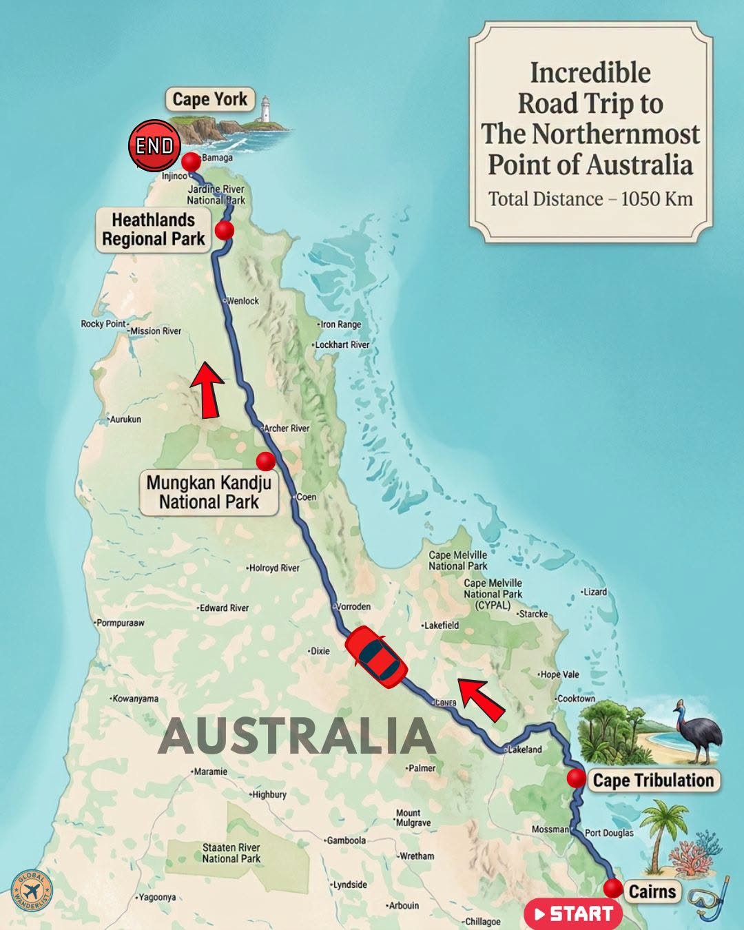
Driving from Cairns to Cape York is one of Australia’s true adventure routes. Over roughly 1,050 kilometers, the road pushes through rainforest, savanna, and remote river crossings before reaching the continent’s northern tip. This is not a route for the unprepared, but it rewards those who make the journey with landscapes few travelers ever see.
A 4WD vehicle is essential for this trip, along with careful planning around river crossings and fuel stops. Below is a full breakdown of the route, including where to eat and what to see along the way.
Route Overview
| Stop | Distance from Previous Stop | Best For |
| Cairns (Start) | – | City base, reef access |
| Cape Tribulation | 140 km | Rainforest meets reef |
| Mungkan Kandju National Park (Coen area) | 460 km | Remote outback scenery |
| Heathlands Regional Park | 300 km | Wetlands, birdlife |
| Cape York/Bamaga (End) | 150 km | Australia’s northernmost point |
Total driving distance runs approximately 1,050 kilometers one way. Most travelers allow one to two weeks to complete the journey and explore stops along the way, given the number of river crossings and unsealed roads.
Cairns
Cairns serves as the launching point for this journey, known internationally as the gateway to the Great Barrier Reef. Before heading north, most travelers spend a day or two here diving, snorkeling, or exploring the Esplanade. It is also the last major city for fuel, supplies, and vehicle checks before the long drive north.
Where to Eat in Cairns
- Ochre Restaurant is widely regarded as one of Cairns’ finest dining experiences, known for its degustation menu featuring native Australian ingredients. It makes a memorable send-off before the remote stretch ahead.
- Tha Fish, located on the pier, offers excellent seafood with waterfront views over the Coral Sea. It is a reliable choice for a relaxed dinner before departure.
What to See in Cairns
- Take a day trip out to the Great Barrier Reef for snorkeling or diving. Several operators run trips directly from the Cairns marina.
- Walk the Cairns Esplanade Lagoon, a free saltwater swimming pool overlooking Trinity Inlet. It is a popular spot for both locals and visitors.
- Visit the Cairns Aquarium to see marine life native to the surrounding reef systems. It offers a good introduction to what you might encounter snorkeling.
Also read: Eastern Australia 5-Weeks Road Trip Itinerary
Cape Tribulation
Cape Tribulation marks the point where the Daintree Rainforest meets the Great Barrier Reef, one of the only places on Earth where two World Heritage sites touch. A car ferry crosses the Daintree River just before reaching this stretch. From here, the road becomes noticeably rougher heading north.
Where to Eat in Cape Tribulation
- PK’s Jungle Village bistro serves straightforward, satisfying meals in a treehouse-style rainforest setting. It has built a loyal following among backpackers and families alike.
- The Daintree Tea House Restaurant is considered the area’s longest-established dining option, popular for lunch. It is also open for dinner with advance reservation.
What to See in Cape Tribulation
- Walk the Dubuji Boardwalk through mangrove forest and rainforest. Interpretive signs explain the unique ecosystem where reef meets rainforest.
- Visit Cape Tribulation Beach itself, framed by rainforest right down to the shoreline. It is one of the most photographed beaches in Far North Queensland.
- Take a guided night walk through the Daintree Rainforest. Nocturnal wildlife, including tree frogs and possums, becomes far easier to spot with a local guide.
Mungkan Kandju National Park (Coen Area)
North of Cape Tribulation, the route passes through increasingly remote savanna country toward Coen, the gateway to Mungkan Kandju National Park. This stretch involves several river crossings and requires careful attention to road conditions, particularly during the wet season. Coen itself is a small township offering essential fuel and supplies.
Where to Eat Near Coen
- The Exchange Hotel in Coen is the area’s classic outback pub, serving simple, hearty meals to travelers passing through. It has operated as the town’s social hub for generations.
- Most travelers through this stretch rely on packed supplies and roadhouse stops, given the limited number of dining options. Stocking up in Cairns or Cooktown beforehand is strongly advised.
What to See in Mungkan Kandju National Park
- Explore the Archer River system, which winds through the park’s savanna woodlands. Birdlife is abundant along the riverbanks.
- Visit the historic Coen township, one of the oldest settlements on Cape York Peninsula. Its old buildings reflect the area’s mining and pastoral history.
- Watch for wildlife along the Peninsula Developmental Road, including wallabies and a wide variety of tropical bird species.
Heathlands Regional Park
Heathlands protects a mix of wetlands, woodlands, and heath vegetation near the top of Cape York Peninsula. It is known for its birdlife and as a habitat for several rare and threatened species. The Jardine River, one of the largest river systems in Cape York, sits just beyond the park’s northern boundary.
Where to Eat Near Heathlands
- Bramwell Station, a working cattle station along the route, offers basic meals and camping facilities for travelers. It serves as one of the last reliable stops before the Jardine River crossing.
- Self-sufficiency is essential through this stretch, since formal restaurants do not exist within the park itself. Most travelers cook at camp using supplies stocked earlier in the trip.
What to See in Heathlands Regional Park
- Look for the park’s diverse birdlife, including palm cockatoos and various honeyeaters found nowhere else in Australia. Birdwatchers consider this one of the country’s premier locations.
- Cross the Jardine River via cable ferry, one of the most memorable moments of the entire drive. The crossing marks the final stretch before reaching the top of the peninsula.
- Explore the surrounding heathland on short walks where accessible. The landscape shifts noticeably compared to the rainforest further south.
Cape York/Bamaga
Bamaga serves as the administrative center for the tip of Cape York, home to several Aboriginal and Torres Strait Islander communities. From here, a final short drive leads to the actual tip, marked by a well-known sign celebrating Australia’s northernmost point. Reaching it is widely considered a rite of passage for serious outback travelers.
Where to Eat in Bamaga
- Cape York Peninsula Lodge offers meals for travelers staying in the area, with a straightforward menu suited to the remote location. It functions as one of the most reliable dining options this far north.
- Seisia, a nearby coastal community, has a tavern serving meals with water views over the Torres Strait. It is a popular stop for those celebrating the completion of the drive.
What to See at Cape York
- Walk out to the tip of Cape York itself, marked by the iconic sign at Australia’s northernmost point. Most travelers take a photo here as proof of the journey.
- Visit Somerset, an old pearling and administrative outpost near the tip. Its ruins offer a glimpse into the area’s colonial history.
- Take a boat trip to Thursday Island in the Torres Strait. The short crossing offers a completely different cultural experience from the mainland.
Also read: Quick Australia Itinerary by Flight: A 14-Day Trip
Final Thoughts
The Cairns to Cape York route is not a casual weekend drive, but for those prepared to take it on, it delivers landscapes and a sense of achievement unlike anywhere else in Australia. Rainforest, savanna, and river crossings all lead to a single, unmistakable finish line at the country’s northern tip. Plan carefully, travel in the dry season, and give the journey the respect it demands.