
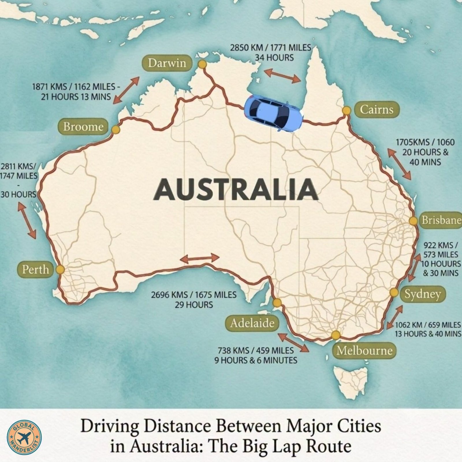
Australia is enormous, and nothing drives that point home quite like planning a road trip between its major cities. The “Big Lap,” a loop connecting Perth, Darwin, Cairns, Brisbane, Sydney, Melbourne, and Adelaide, covers a continent roughly the size of the continental United States. Understanding the actual driving distances and times between these hubs is essential before committing to any leg of the journey.
This guide breaks down the key distances around Australia’s coastal perimeter, along with what each leg of the drive actually involves. Whether you are planning the full lap or just one long-distance stretch, knowing what you are signing up for makes all the difference.
Big Lap Route Overview
| Route | Distance | Approx. Drive Time |
|---|---|---|
| Melbourne to Sydney | 1,062 km | 13 hours 40 minutes |
| Sydney to Brisbane | 922 km | 10 hours 30 minutes |
| Brisbane to Cairns | 1,705 km | 20 hours 40 minutes |
| Cairns to Darwin | 2,850 km | 34 hours |
| Darwin to Broome | 1,871 km | 21 hours 13 minutes |
| Broome to Perth | 2,811 km | 30 hours |
| Perth to Adelaide | 2,696 km | 29 hours |
| Adelaide to Melbourne | 738 km | 9 hours 6 minutes |
These figures reflect direct, non-stop driving time on sealed highways, without accounting for fuel, rest, or sightseeing stops. In practice, most travelers spread the full lap across four to six months to properly experience the country along the way.
Melbourne to Sydney
This leg follows the Hume Highway, Australia’s busiest interstate route, connecting the country’s two largest cities. Most of the drive runs through rural New South Wales and Victoria, passing towns like Albury-Wodonga and Goulburn. It is comfortably achievable as a two-day drive with an overnight stop.
Practical Driving Tips
- Break the journey with an overnight stop in Albury-Wodonga or Canberra, both roughly halfway between the two cities.
- Avoid departing either city during Friday afternoon peak hour, since traffic can add significant time near both metro areas.
- Fill up regularly, since fuel prices along this corridor are generally competitive compared to more remote stretches further north.
Sydney to Brisbane
The Pacific Highway links Sydney to Brisbane along the New South Wales coast, passing through Newcastle, Port Macquarie, and Byron Bay. This route has been significantly upgraded in recent years, cutting travel time compared to older sections of the highway. Most travelers stretch this drive across two to three days to properly enjoy the coastline.
Practical Driving Tips
- Book accommodation in Byron Bay well ahead of time, since it remains one of the most popular overnight stops on this route.
- Watch for reduced speed zones through coastal towns, where traffic cameras are common along the highway.
- Consider detouring inland briefly through the Gold Coast hinterland if you have extra time, since it offers a cooler break from coastal humidity.
Brisbane to Cairns
The Bruce Highway carries travelers from Brisbane through Queensland’s tropical coast to Cairns, passing towns like Rockhampton, Mackay, and Townsville. At over 1,700 kilometers, this is one of the longer coastal legs of the Big Lap. Most travelers take four to five days to cover it comfortably, given the number of worthwhile stops along the way.
Practical Driving Tips
- Plan overnight stops in Rockhampton, Airlie Beach, and Townsville to break the drive into manageable sections.
- Watch for wildlife on the road at dawn and dusk, particularly kangaroos and cassowaries in more rural stretches.
- Check for flooding alerts during the wet season between November and April, since sections of the Bruce Highway can experience closures.
Cairns to Darwin
This is the most demanding stretch of the entire Big Lap, cutting across the Gulf of Carpentaria and into the Northern Territory. At roughly 2,850 kilometers, it typically takes five to seven days including rest stops, given the remoteness of much of the route. Fuel stops become considerably sparser here compared to the eastern coastal legs.
Practical Driving Tips
- Fill your tank at every opportunity, since some stretches between roadhouses can exceed 200 kilometers.
- Carry extra water and basic supplies in case of vehicle trouble, since mobile coverage is patchy across much of this route.
- Plan your crossing during the dry season between May and October, since wet season flooding can close sections of the road entirely.
Also read: Cairns to Cape York Road Trip Idea
Darwin to Broome
The Victoria Highway and Great Northern Highway connect Darwin to Broome through the Kimberley region, one of Australia’s most remote and visually striking areas. At around 1,871 kilometers, this leg passes through Katherine and Kununurra before reaching the Western Australian coast. Most travelers take four to five days to properly explore the gorges and national parks along the way.
Practical Driving Tips
- Detour into Kakadu National Park near the start of this leg if time allows, since it sits just off the main route from Darwin.
- Book accommodation in Kununurra ahead of time, since it serves as the main service town for a long stretch of this drive.
- Check road conditions carefully during the wet season, since river crossings in this region can become impassable after heavy rain.
Broome to Perth
This is the longest single leg of the Big Lap, tracing Western Australia’s coastline for over 2,800 kilometers. The route passes through Port Hedland, Exmouth, and Geraldton before reaching Perth. Most travelers spread this drive across a full week or more, given the number of significant stops, including Ningaloo Reef and Karijini National Park.
Practical Driving Tips
- Detour to Karijini National Park near Tom Price if you have extra days, since it sits a short distance off the main coastal route.
- Plan whale shark tours around Exmouth well in advance, since the season runs roughly from March to July.
- Carry extra fuel reserves through the more remote central stretch between Port Hedland and Carnarvon.
Perth to Adelaide
This leg crosses the Nullarbor Plain, one of the longest straight stretches of road in the world. At nearly 2,700 kilometers, it typically takes four to five days including rest stops. The Nullarbor crossing itself is remote and largely featureless, making fuel and water planning essential.
Practical Driving Tips
- Fill your tank at every roadhouse across the Nullarbor, since distances between fuel stops can exceed 200 kilometers.
- Watch for southern right whales near the Head of Bight between June and October, visible from several coastal lookouts.
- Carry paper maps as a backup, since mobile coverage disappears for long stretches across the plain.
Adelaide to Melbourne
The final leg of the Big Lap connects Adelaide back to Melbourne, generally considered the easiest and shortest stretch of the entire loop. Multiple route options exist here, including a direct inland path and a longer coastal route through the Great Ocean Road. Most travelers complete this leg comfortably in a single day, though it easily extends to two or three with detours.
Practical Driving Tips
- Choose the coastal route through the Great Ocean Road if time allows, since it adds some of Australia’s best scenery to an otherwise straightforward drive.
- Book Great Ocean Road accommodation ahead during summer and long weekends, since this stretch gets busy with domestic travelers.
- Consider the direct inland route via the Western Highway if you are short on time, since it shaves several hours off the coastal alternative.
Final Thoughts
The Big Lap represents one of the most ambitious road trips in the world, and understanding the real distances involved is the first step in planning it properly. Some legs, like Adelaide to Melbourne, are easy weekend drives. Others, like Cairns to Darwin, demand serious preparation and respect for the remoteness involved. Whether you tackle the full loop or a single leg, knowing what lies ahead makes the journey far more enjoyable.