
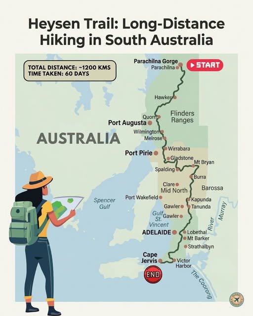
The Heysen Trail is a long hiking trail in Australia, stretching around 1,200 kilometers from Cape Jervis on the Fleurieu Peninsula to Parachilna Gorge deep in the Flinders Ranges. Most end-to-end hikers take between 55 and 65 days to complete it, though the vast majority of walkers tackle it in shorter sections instead. The trail moves through coastal cliffs, wine country, historic mining towns, and some of the oldest mountain ranges on Earth.
Named after Sir Hans Heysen, the landscape painter whose work made the Flinders Ranges famous, the trail was built in stages through the 1970s and 1980s before fully opening in 1992. Red and white markers guide the way, though sections through private land close during the fire danger season between roughly December and March. Below is a full breakdown of the route, along with what to see and practical tips for each stretch.
Route Overview
| Section | Approx. Distance from Previous Stop | Terrain Highlight |
|---|---|---|
| Parachilna Gorge (Start) | – | Rugged Flinders Ranges |
| Hawker & Wilpena Pound | 80 km | Ancient rock formations |
| Quorn & Port Augusta | 90 km | Pichi Richi Pass |
| Melrose & Mount Remarkable | 60 km | Forested peaks |
| Mid North (Clare Valley & Burra) | 150 km | Vineyards, mining history |
| Barossa Valley | 100 km | Wine country |
| Adelaide Hills | 90 km | Rolling farmland, lookouts |
| Fleurieu Peninsula & Cape Jervis (End) | 130 km | Coastal cliffs, Kangaroo Island views |
Total trail distance runs close to 1,200 kilometers. Most walkers agree the strongest sections sit at either end, closer to Parachilna Gorge and around Cape Jervis, where the scenery is at its most dramatic.
Parachilna Gorge & Wilpena Pound
The Heysen Trail’s northern terminus sits at Parachilna Gorge, deep in the Flinders Ranges. This opening stretch passes through the Aroona Valley, where Hans Heysen himself once painted many of his best-known works. Wilpena Pound, a massive natural amphitheater of mountains, dominates much of this section’s scenery.
Trail Highlights
- Walk through the Aroona Valley, the site of several of Hans Heysen’s most famous landscape paintings.
- Visit Wilpena Pound, a natural rock basin so large it can only be fully appreciated from the air or a high lookout.
- Camp at Yanyanna Hut or Trezona campground, both positioned for spectacular sunrise views over the Bunyeroo Valley.
Planning Tips for This Section
- Carry significantly more water than usual, since this stretch of the Flinders Ranges is genuinely remote and water sources are scarce.
- Walk this section between April and November, since summer heat here can become dangerous for hikers.
- Allow three to four days to properly cover this opening stretch, camping at either Aroona Valley or Trezona along the way.
Hawker to Quorn & Port Augusta
South of Wilpena Pound, the trail passes through Hawker before reaching Quorn, a historic railway town at the base of the Flinders Ranges. Pichi Richi Pass, once a route for the old Ghan railway, cuts dramatically through this stretch. Port Augusta sits nearby as a larger regional service center.
Trail Highlights
- Ride or walk alongside the historic Pichi Richi Railway line, still operated as a heritage steam train through the pass.
- Explore Quorn’s well-preserved railway heritage, including its old station buildings and pubs.
- Watch for wedge-tailed eagles and euros, both common sightings across this stretch of semi-arid ranges.
Planning Tips for This Section
- Resupply in Quorn or Port Augusta, both offering full services before the trail continues south into more remote terrain.
- Check current fire restrictions before setting out, since this region experiences some of the trail’s harshest summer conditions.
- Expect long, exposed stretches with little shade, so plan water and sun protection carefully.
Melrose & Mount Remarkable National Park
Melrose, one of South Australia’s oldest towns, sits at the base of Mount Remarkable National Park. This section introduces noticeably more forested terrain compared to the open ranges further north. The climb up Mount Remarkable itself is considered one of the trail’s more physically demanding stretches.
Trail Highlights
- Climb Mount Remarkable for sweeping views back over the southern Flinders Ranges and surrounding farmland.
- Explore Melrose’s historic streetscape, widely considered one of the prettiest small towns in South Australia.
- Walk through Alligator Gorge, known for its narrow, colorful rock walls within the national park.
Planning Tips for This Section
- Break up the Mount Remarkable climb with an early start, since the ascent is steep and best tackled before the day heats up.
- Stay in Melrose to resupply and rest, since it offers a good range of accommodation for a trail town of its size.
- Watch the weather closely here, since conditions in the ranges can shift quickly from mild to extreme heat.
The Mid North: Clare Valley & Burra
South of Mount Remarkable, the trail enters South Australia’s Mid North, passing through Clare Valley wine country and the historic mining town of Burra. This stretch offers a noticeable change of pace, with vineyards and heritage buildings replacing the rugged ranges further north. It is considered one of the more comfortable sections for resupply and accommodation.
Trail Highlights
- Visit Burra’s former Monster Mine, once one of the largest copper mines in the British Empire during the 1800s.
- Stop at Clare Valley wineries for a break from walking, many offering cellar door tastings just off the main trail.
- Explore Mount Bryan, one of the highest points in this section, offering wide views over the surrounding farmland.
Planning Tips for This Section
- Take advantage of the region’s accommodation options, since towns here are more closely spaced than in the Flinders Ranges further north.
- Book cellar door visits ahead if you want a sit-down meal, since many wineries keep limited hours outside peak season.
- Use this stretch to resupply thoroughly before continuing toward the Barossa Valley.
Barossa Valley
The Heysen Trail passes directly through the Barossa Valley, one of Australia’s most famous wine regions. Vineyards, historic Lutheran churches, and rolling hills define this section. It offers one of the more relaxed stretches of the entire trail, both in terrain and available services.
Trail Highlights
- Walk past vineyards in Tanunda and Kapunda, both towns known for their strong German settlement heritage.
- Visit Mount Crawford Forest, a mix of native and plantation woodland forming part of this stretch.
- Stop at a Barossa cellar door for a well-earned glass of Shiraz, the region’s signature variety.
Planning Tips for This Section
- Book accommodation in Tanunda or Nuriootpa ahead of time during vintage season, when the region gets noticeably busier.
- Take advantage of relatively easy terrain here to make up time if earlier sections ran behind schedule.
- Restock supplies thoroughly, since the towns through this stretch offer some of the best services on the entire trail.
Adelaide Hills
South of the Barossa, the trail climbs into the Adelaide Hills, passing through Lobethal and Mount Barker before descending toward the coast. Rolling farmland and high ridgelines offer wide views back toward Adelaide’s city skyline. This section marks the transition from wine country toward the coastal Fleurieu Peninsula.
Trail Highlights
- Walk through Mylor and toward Mount Lofty, taking in panoramic views over Adelaide and the surrounding hills.
- Visit Lobethal, another historic Lutheran settlement town with well-preserved colonial architecture.
- Pass through Kuitpo Forest, a shaded stretch of tall eucalypt offering relief from the open hills nearby.
Planning Tips for This Section
- Use this stretch’s proximity to Adelaide to arrange easy transport if you need to pause your hike partway through.
- Expect busier trail sections here, since day walkers frequently use parts of this stretch close to the city.
- Take advantage of good phone coverage in this region to check weather and trail conditions further south.
Fleurieu Peninsula & Cape Jervis
The trail’s final stretch runs through the Fleurieu Peninsula, finishing at Cape Jervis on the southern coast. Deep Creek Conservation Park offers some of the most dramatic coastal scenery on the entire route, with cliffs looking out toward Kangaroo Island. Many hikers consider this closing section, alongside the Flinders Ranges opening, the trail’s finest stretch.
Trail Highlights
- Walk through Deep Creek Conservation Park, known for its sea cliffs, heathland, and views across Backstairs Passage to Kangaroo Island.
- Visit Victor Harbor, a popular coastal town roughly 60 kilometers before the trail’s southern end.
- Finish at Cape Jervis, marked by a small trail post near the SeaLink ferry terminal.
Planning Tips for This Section
- Time your final days to coincide with calm coastal weather, since this stretch is fully exposed to Southern Ocean winds.
- Book a ferry crossing to Kangaroo Island in advance if you want to extend your trip after finishing at Cape Jervis.
- Arrange return transport to Adelaide ahead of time, since Cape Jervis itself has limited onward transport options.
Also read: Hiking in Australia: Bibbulmun Track
Final Thoughts
The Heysen Trail captures an extraordinary cross-section of South Australia, from the ancient ranges of the Flinders to the wine country of the Barossa and the cliffs of the Fleurieu Peninsula. Most walkers take it on in sections rather than one continuous hike, and either approach rewards the effort. Plan around the cooler months between April and November, carry plenty of water through the northern ranges, and let the trail’s changing landscapes carry you from outback gorge to ocean cliff.